mud, petroglyphs, oil, and fire: quintessentially azerbaijan

Sandwiched in the Caucasus, between the Caspian and Black Seas, Azerbaijan is a bit of a latecomer to global tourism. But catching up fast.

Unusual on multiple counts, four features and their unique mix set the country even further apart from the ordinary: Mud, petroglyphs, oil, and fire. Where else can one find such a cocktail! To add to its appeal, they come candy-wrapped in picturesque settings at a short distance from the capital Baku in the surrounding Absheron Peninsula.

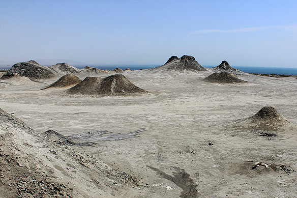
Of the 700 mud volcanoes found around our planet, 40 percent lie in Azerbaijan. They bubble away on barren stretches courtesy of methane gas trapped under the earth’s crust. When the pressurized gas encounters groundwater, and together they find an opening in a fault line, they ooze out in the form of mud, cool to the touch.

Ranging from 1 to 700 metres high, and a few centimetres to a few kilometres wide, they function similarly to regular volcanoes. When they erupt, they can spew flames and mud from the bowels of the earth. Kinezadagh [397 metres high] and Turaghay [400 metres high] are the largest mud volcanoes in the country.

Azerbaijan is also among the oldest inhabited regions in the world, going back to the Stone Age. The Gobustan Rock Art Cultural Landscape Reserve, a UNESCO-listed World Heritage Site, contains an exceptionally large collection of petroglyphs. Etched into rock with sharp stone tools, and with the advent of the Bronze and Iron Ages, with metal, the earliest of the lot is 40,000 years old.

Subjects range from dancing figures, shamans, boats with oarsmen, and battle and hunting scenes; the latter replete with bison, gazelles, horses, and goats. Some of these were ‘drawn’ even before the region’s ancient men and women shifted to farming and husbandry as a source of food. Continue reading

the road less travelled: azerbaijan’s unusual villages

In just five to six hours, one can traverse across Azerbaijan’s length or breadth, crossing nine of the world’s 11 climatic zones along the way. And whilst at it, you would most likely not pass another soul.

Of Azerbaijan’s population amounting to just over 10 million, almost half of these live and work in the capital city Baku and the surrounding Absheron peninsula. The rest of the country is deserted. A tiny village tucked away in a forest-canopied valley or perched on a mist-wrapped mountain is as busy as it gets, apart from a handful of administrative and historical towns.

Nature is at its most magnificent on these stretches, free of exploitation for commercial gains and plastic waste. It is a setting which has also created some of the world’s most unique villages.

Take for instance Lahij, a thousand-year-old Persian village on the southern slopes of the Greater Caucasus Mountains. Unable to find suitable building material, the villagers created an entire settlement of homes and roads with river boulders. Over the centuries they also developed copper handicrafts of exquisite workmanship. It is a craft that is still practiced by its residents and has been listed in UNESCO’s Intangible Cultural Heritage of Humanity.

Then there are the villages in Lerik district in the foothills of the Talysh Mountains in south-east Azerbaijan where centenarians are the norm. Home to some of the oldest people that have ever lived on earth, the Talysh people, also of Persian descent, can be seen working on their fields and grinning cheerfully way into their hundredth birthday. At 90, they would be quick to exclaim that they still felt incredibly young!

If Lerik is about villagers renowned for their longevity, Khinalig high up in the Greater Caucasus range is the oldest inhabited village in the world—historians place it at 5,000 years. Its semi-nomadic villagers travelling between pastures have their own language, possess a distinct genetic make-up, and till recently had no contact with the rest of the world. Together with the mountains encircling it, the village and its inhabitants are a UNESCO-listed World Heritage Site.

Fascinating, isn’t it? Here are some more insights into these villages and their incredible secrets on the road less travelled, this time in the mountains of Azerbaijan.

Oh, and when on that road, don’t forget to have a qutab and chai from one of the many eateries nestled deep in dark lush forests. 😊 Continue reading

travel shorts: a tale of two heritage cities—shamakhi and sheki in azerbaijan

This slideshow requires JavaScript.

This is the tale of two cities in the land of fire, oil, and gas: Shamakhi where Azerbaijan’s rich medieval heritage took birth. And Sheki, which witnessed this same heritage’s closing chapter before the country was enveloped, first into the Russian empire and soon after, into the Soviet Union.

One specific dynasty’s rule had dominated Azerbaijan’s windswept plains and highlands in the Middle Ages. They were the Shirvan Shahs who ruled the Shirvan region, and whose capital Shamakhi was a trading post on the famed Silk Road.

Such was the glory and power of the Shirvan Shahs that their capital Shamakhi flourished for seven hundred years, from the 9th to 15th Centuries. When it did end its role as their capital, it was only because of nature’s unpredictable jostles. Shamakhi was prone to earthquakes. In the 15th Century, after one of the worst earthquakes the city had seen till then, its rulers felt it was wiser to move their capital lock-stock-and-barrel to Baku.

Most of Shamakhi was razed to the ground in this earthquake. Except for Juma Mosque, Caucasus’ second oldest mosque dating to 743. Juma or Friday Mosque has consistently, and lovingly, always been restored over the centuries. Its most recent face-lift was in 2013. Continue reading

the 5 untold treasures of abu dhabi and sharjah

Think of the United Arab Emirates [UAE] and the one city that invariably pops up in our minds is Dubai—the city of steel, glass, and gold. But Dubai is not the only emirate. Notice the plural in the country’s name? There are six others, each with its own ruler, and of these, two are steadily vying with Dubai for a space in global tourism. For a reason: The incredible treasures they both hold which not many know about. They are Abu Dhabi and Sharjah.

Abu Dhabi is the richest emirate in the grouping and its city by the same name, Abu Dhabi, is the country’s capital. 96 percent of the UAE’s 100 billion barrels of proven oil reserves are within its borders, ranking it at number six worldwide. Abu Dhabi’s ruler is also the President of the UAE. Sharjah, on the other hand, is in a time-warp. It is older, more traditional, and regarded as the UAE’s cultural capital.

It was in 1958 when the UAE first discovered it had oil, and that too loads of it. Four years later, in 1962, Abu Dhabi, then a small fishing village on the edge of a desert, exported its first cargo of crude oil, and the country changed forever.

Supplying 4 percent of the world’s oil requirements with a production of 3.2 million barrels per day, the UAE has spiralled its way through progress at an astonishing speed. However, there is another side to the country that was formed on 2nd December, 1971. Its pre-oil era, swathed in a heritage that is beyond its oil. There is also a whole country that is beyond Dubai.

With ancient desert roots and a vision of unity through globalisation, here are some of UAE’s most spectacular treasures in its two lesser visited cities Abu Dhabi and Sharjah. For often the most beautiful sites are on the road less trodden. ❤ Continue reading

kullu manali and their 11 loadstones

Loadstone: Noun. A person or thing that is the focus of attention or attraction. In aplenty. In other words—Kullu and Manali.

– – –

Two of India’s most popular hill stations’ names are often taken in the same breath. Even though they are separated by some 40-odd kilometres.

Welcome to Kullu Manali. Two towns located on the verdant Kullu valley in India’s Himachal Pradesh with the ice-blue Beas river gurgling past them.

Free of a colonial overprint, or the culture and faith of an invading ruler, these two towns have in the past, as well as today, continue to epitomize Himachal history, traditions, and heritage. In all its unadulterated richness.

Gods are in abundance here, and so are centuries-old beliefs. The lines between mythology and mundane reality are blurred with characters from the epics Mahabharata and Ramayana popping up everywhere. Ancient sages, mythical heroes, demons, and the proverbial Noah [in Hinduism’s case Manu] who set forth from his ark to kick-start the lineage of mankind. They are all somehow associated with the Kullu valley which has earned itself the moniker ‘Valley of Gods.’

There’s also tall graceful fir trees, rivers fed by melting glaciers punctuated with hot water springs, and wooden homes which have housed many a generation of pahari [mountain] folks inside their weathered walls.

You will need at least a few days to get acquainted with Kullu and Manali’s sites. Hotels and taxis are easily available. Let me not go into them here. Rather let this post be a roadmap of what makes these two towns attract pilgrims and tourists in their droves, always. ❤ Continue reading

the complete travel guide to the treasures of sri lanka’s cultural triangle

Welcome to my travel guide on Sri Lanka’s Cultural Triangle told a bit differently—through short photo-essay chapters on the country’s ancient and medieval history.

Of the six UNESCO-listed cultural world heritage sites in Sri Lanka, five lie within the Cultural Triangle in the heart of the country. It is a region rooted in 2,500 years of history and heritage, both sacred and secular, from timeless Theravada Buddhist sites to splendid Sinhalese royal capitals. All surrounded in lush tropical jungles.

Before I write any further, I would like to briefly explain two terms used in this guide which are part of the warp and woof of the country. Theravada Buddhism and ‘Sinhalese.’ Theravada Buddhism is the oldest school of Buddhism and a direct offshoot of Buddha’s teachings. There are five countries in the world which have Theravada Buddhism as their official religion, and Sri Lanka is one of them. Sinhalese refers to the Indo-Aryan ethnic race native to Sri Lanka.

Whilst this guide covers the five UNESCO-listed sites, it also includes some gems scattered in-between. I hope you find it useful and it helps put the country’s Cultural Triangle as a seamless whole with all the dots connected. ❤

[Title photo: 18th Century Mural at Lankatilaka Vihara, Kandy.]

Table of Contents:

Continue reading

jaffna: the unexplored north of sri lanka

Twenty-six years of civil war is a long time. A whole generation grows up exposed to the horrors of war, stripped of their right to education, health-care, and utilities. It is hard for one living in a ‘secure’ country to even fathom such dreadfulness day in and day out, year in and year out.

Sri Lanka’s LTTE-Sinhalese civil war started on 23 July, 1983 and ended on 19 May, 2009, during which an estimated 40,000 civilians died according to a UN Experts Report. Those who could leave, left the country. Root causes of the civil war were a series of anti-Tamil riots following independence in 1948 and the 1956 Government Act which recognized Sinhalese as the only official language.

Fuelled further by the government’s citizenship and education policies, it led to the creation of the LTTE or Tamil Tigers, as they were known, and their demand for a separate Tamil state ‘Tamil Eelam.’

Suicide bombers were a trademark of the Tamil insurgency. Even India, Sri Lanka’s neighbour, could not be immune to it. India’s ex-Prime Minister Rajiv Gandhi was assassinated in 1991 by a 22-year-old female LTTE suicide bomber.

Jaffna [Yalpanam in Tamil] on the northern tip of Sri Lanka, was the epicentre of this civil war which spread across the island’s northern and eastern coastlines. Mutilated factories, bombed homes, and walls pock-marked with gunshots are still scattered throughout the city and its surrounds. An echo of its turbulent past.

Three things, by some miracle, have survived from the nearly three decades of fighting: One, the region’s places of worship—magnificent colourful Hindu temples, poignant grand churches, and sacred Buddhist sites—two, its bygone colonial ruins, and three, a bunch of remote sleepy isles on the Palk Strait in the Indian Ocean. Continue reading

the sigiriya frescoes: king kassapa I and his 500 damsels

477 AD. Anuradhapura, Sri Lanka.

29-year-old Prince Kassapa I was filled with a deep burning desire to be king. So deep, it seemed to completely engulf him. To be the ruler of Anuradhapura, Sri Lanka’s ancient historical spiritual heart. How wondrous would that be!

And he would have been. Could have been. Except for one problem. His mother was the non-royal wife of Moriya King Dhatusena. The rightful heir to the coveted throne was his young half-brother Moggallana, offspring of his father’s chief consort.

Not to be deterred, Kassapa I, also known as Kashyapa I, decided to lead a palace coup with the help of Migara, the army commander who had a personal grudge of his own against the king. Young Moggallana, meanwhile, managed to escape, and took refuge in South India.

When Kassapa demanded to know the location of his father’s treasury, his imprisoned father responded saying Anuradhapura’s water tank was his one-and-only treasure. Miffed on hearing this, Kassapa had his father entombed alive.

For the rest of his life, Kassapa’s subjects and rivals, as well as the local Buddhist monks, would call him Pithru Ghathaka Kashyapa meaning Kashyapa the Patricide. It was a label he would not be able to shake off even after death.

In a bid to start afresh, away from public disgrace and the threat of a possible future retaliation by Moggallana, Kassapa moved his capital 75 kilometres south. Here, deep in Sri Lanka’s tropical plains stood a 180-metre-high monolith volcanic rock pillar with unhindered 360-degree views for miles on end. Continue reading

11 memorable experiences only to be had in turkmenistan

Tourist number: 1933.

It is the early hours in the morning of 1 October, and I am at the gleaming falcon-shaped marble-encased airport in Ashgabat, capital of Turkmenistan. I ask the official at the visa counter what does this line on my entry stamp mean. He explains that 1,932 tourist visas had been issued in 2023 before mine. I am 1,933rd. This does not include the 3-to-7-day transit visas, by-the-way.

With a silly grin plastered on my face, I tell him he has no idea how much it means to have that sticker on my passport. Many months of planning and three back-to-back flights, from Goa to Muscat to Dubai to Ashgabat, and I am finally, finally here.

I guess my enthusiasm is contagious. The otherwise poker-faced official gives a little smile and wishes me a happy stay. I respond with a beaming grin.

Outside, shifting lights on the airport’s facade recreate a falcon’s flapping wings. Continue reading

persian herat and its hidden wonders

Right at the very end of the battered and bruised road, cutting across the country from east to west, is the Persian historical city of Herat. Not many travellers come this far. It is way too out, perched near Afghanistan’s western border with Iran. Yet, it has always been of great importance, as is revealed by its architectural and cultural treasures to those who take the trouble to reach it.

Herat’s been around for a long time; 6th Century BC records describe it as a Persian city which went by the name Aria. Yes, the same pronunciation as my surname. 🙂

Its strategic location on the Great Silk Road and the banks of the Hari River made it particularly appealing to conquerors and rulers. Alexander the Great defeated Herat’s Persian Achaemenids in 330 BC and put up a majestic citadel to celebrate his victory. He was followed by the Abbasid Caliphs in the 8th Century, Ghurids in 1175, the Mongol Genghis Khan who destroyed everything in 1221, the Kartids who then rebuilt it, and the Timurid Tamerlane who destroyed it once again in 1380.

When Tamerlane’s favourite son Shahrukh Mirza decided to move his capital from Samarkand to Herat, he was determined to make Herat the grandest city in the region. A vision shared by his wife Gawhar Shad and later descendent Husayn Bayqara.

The result was a city of much beauty and grace whose praise was extolled far and wide. Of its many buildings, 830 ‘cultural sites’ are still believed to survive today, warranting it a place in UNESCO’s tentative list in 2004.

It is a difficult combination. War and conservation. However, despite all the odds, both UNESCO and the Aga Khan Trust for Culture have consistently worked on Herat, ensuring its treasures, hidden from the world at large, manage to survive.

Come along with me on a virtual tour of Timurid Herat, the city on the Hari River, to see why it was called the ‘Pearl of the Khorasan’ for the longest time! Continue reading