
Kazakhstan, the world’s ninth largest country, is not all golden steppe land. The country boasts some of the most incredible geographical wonders as well, especially in its southern recesses.
Accessible from the country’s former capital Almaty, they consist of an eclectic array of lakes and canyons which would leave even the most jaded traveller starry-eyed. Yes, they are that beautiful. To ensure they stay beautiful, they are protected under the UNESCO national network of biosphere reserves.
Unless you have the luxury of unlimited time in the country, along with your own transport, it would not be possible to strike them all off a bucket list. Do not even try!
Those that are accessible, not because of any seamless public transport, but rather courtesy of a handful of day trips, are luckily the best of the lot.
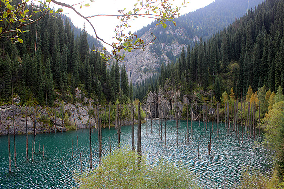
When it comes to lakes, Lake Kaindy, literally meaning both ‘birch tree’ lake and ‘landslide’ wins hands down. And it is not simply for its scenic beauty with bare birch tree trunks rising from deep turquoise-blue waters as a result of yes, you guessed right, a landslide. It also trumps the popularity list because of the adrenalin-filled journey needed to reach it.
This comes in the form of a hair-raising offroad adventure across rivers and boulders in Soviet-era vans accompanied with loud Russian rap, followed by a steep downhill walk to the lake’s shores. You could of course just hike the whole way or take a horse ride, but naa, that would be so tame.