photo essay: mountains, desert, and coast of northern oman

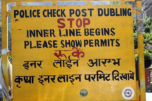
If you look closely at Oman’s map you will notice a peculiar detail. There is the mainland, and separated from it is its governate Musandam on a peninsula jutting into the Strait of Hormuz. Look more closely. You will see an exclave [called Madha] between the two that is surrounded by the UAE. Look at it even more closely. Within Madha is Nahwa, an enclave that belongs to the UAE.

Now you may well ask, how did this happen?

Somewhere around the late-1930s, the four rival sheikhs controlling the surrounding area asked Madha’s village elders who did they want to pledge their allegiance to? Madha chose the Sultanate of Oman, but the bit inside it called Nahwa chose the Arab Emirates. Based on their choice, the rather unusual border between the UAE and Oman was drawn out in 1969.

That is Oman for you.

The eclectic set of borders further transposes into an eclectic set of mountains, desert, and coastline, juxtaposed right next to each other. It is as if the gods asked them too, whose realm did they choose, and they all in unison said “Oman.”

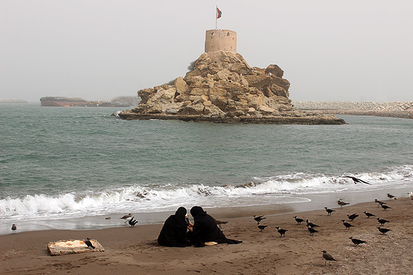
Described as a geologist’s paradise, the oldest continuously independent nation in the Arab World [since 1650] has held on to its authenticity well. Despite being a high-income country, there is no rivalry for high rises in the Sultanate of Oman, nor glitzy shows of oil wealth.

Come travel with me through my photo essay across northern Oman as I take you from Muscat to Fins Beach via the Bimmah Sinkhole and Wadi Tiwi, on to Ras Al-Hadd to see turtles and Sur to see dhows, camp under the stars in the Sharqiya Sands, stop by at a Bedouin market in Sinaw, have meals at traditional mud settlements, drive offroad to the top of Jebel Shams and then down Wadi Bani Awf, to be back in Muscat. And on the way, learn about this fascinating country and its warm, laid-back, friendly people. ❤


The journey begins. Continue reading

the road less travelled: azerbaijan’s unusual villages

In just five to six hours, one can traverse across Azerbaijan’s length or breadth, crossing nine of the world’s 11 climatic zones along the way. And whilst at it, you would most likely not pass another soul.

Of Azerbaijan’s population amounting to just over 10 million, almost half of these live and work in the capital city Baku and the surrounding Absheron peninsula. The rest of the country is deserted. A tiny village tucked away in a forest-canopied valley or perched on a mist-wrapped mountain is as busy as it gets, apart from a handful of administrative and historical towns.

Nature is at its most magnificent on these stretches, free of exploitation for commercial gains and plastic waste. It is a setting which has also created some of the world’s most unique villages.

Take for instance Lahij, a thousand-year-old Persian village on the southern slopes of the Greater Caucasus Mountains. Unable to find suitable building material, the villagers created an entire settlement of homes and roads with river boulders. Over the centuries they also developed copper handicrafts of exquisite workmanship. It is a craft that is still practiced by its residents and has been listed in UNESCO’s Intangible Cultural Heritage of Humanity.

Then there are the villages in Lerik district in the foothills of the Talysh Mountains in south-east Azerbaijan where centenarians are the norm. Home to some of the oldest people that have ever lived on earth, the Talysh people, also of Persian descent, can be seen working on their fields and grinning cheerfully way into their hundredth birthday. At 90, they would be quick to exclaim that they still felt incredibly young!

If Lerik is about villagers renowned for their longevity, Khinalig high up in the Greater Caucasus range is the oldest inhabited village in the world—historians place it at 5,000 years. Its semi-nomadic villagers travelling between pastures have their own language, possess a distinct genetic make-up, and till recently had no contact with the rest of the world. Together with the mountains encircling it, the village and its inhabitants are a UNESCO-listed World Heritage Site.

Fascinating, isn’t it? Here are some more insights into these villages and their incredible secrets on the road less travelled, this time in the mountains of Azerbaijan.

Oh, and when on that road, don’t forget to have a qutab and chai from one of the many eateries nestled deep in dark lush forests. 😊 Continue reading

part 3: the spiti trilogy: lahaul, the mystical side of life and himachal

Prayer flags at Kunzum Pass. Because the gods live in the mountains.

Prayer flags at Kunzum Pass. Because the gods live in the mountains.

Welcome to part 3 of my photo diary trilogy on Kinnaur, Spiti, and Lahaul, high up in the Himalayas in India’s Himachal Pradesh.

If Kinnaur is all about the lush flourishing side of living, and Spiti the very opposite—about its barrenness, then Lahaul is the natural outcome of going through both sides of life. It is of tuning in with one’s inner self. I guess you could simply also describe it as meeting one’s Maker.

Here in Lahaul, Buddhist chants echo from monasteries perched atop peaks. Lakes contain deities and so do mountain passes. There is the sacred everywhere, and it is celebrated with much joy.

I would like to share my journey through Lahaul valley with you here. Maybe its magic captures your heart and soul too. 🙂

Continue reading

part 2: the spiti trilogy: spiti, the barren side of life and himachal

Buddha statue in Langza Village. Because the gods live in the mountains.

Buddha statue in Langza Village. Because the gods live in the mountains.

Welcome to part 2 of my photo diary trilogy on Kinnaur, Spiti, and Lahaul.

This week’s post is about Spiti, a cold desert biosphere in the rain shadow area of the Himalayas bordering Tibet. India’s monsoons do not reach here. Even if they do manage to squeeze their way past the soaring peaks, all they are able to muster is a drizzle. The summers are always dry. The winters are covered in thick snow and ice.

None of which is conducive to agriculture except if carried out on the banks of the Spiti river. The land is otherwise brown and barren, its moonscapes strewn with sand and boulders. Nestled in this arid bleakness are countless ancient monasteries, bedecked and bejewelled with Tibetan Tantric Buddhist iconography. These pockets of sanctity serve as places of refuge, giving strength and meaning beyond a difficult life.

Come along with me to Spiti.

Continue reading

part 1: the spiti trilogy: kinnaur, the verdant side of life and himachal

Sangla valley—Sangla means 'Pass of Light' in Tibetan language. Because the gods live in the mountains.

Sangla valley—Sangla means ‘Pass of Light’ in Tibetan language. Because the gods live in the mountains.

I have always seen myself as an ocean person. I love the rhythm of crashing waves, the smell of salt in the sea air, the white foam breaking into froth around my feet, and tugging me along as it leaves.

And then I went to the Lahaul and Spiti valleys and everything changed inside of me. I became a mountain soul. Those who have been there will understand what I mean.

The Lahaul and Spiti district in India’s northern state of Himachal Pradesh is one of the most beautiful places I have travelled to. Remote and untouched, its offroad route is accessed through neighbouring Kinnaur district if coming in from the Shimla side. When exiting, it continues to Manali to form a loop. Kinnaur and Lahaul are both verdant and green. Sandwiched between them, Spiti, in stark contrast, is a high mountain barren desert perched on the soaring Himalayan range, wild and windswept.

Starting with today, I will be posting a photo diary trilogy of Kinnaur, Spiti, and Lahaul over the coming three weeks. Care to join me and let your soul fall in love with the mountains too? ❤

Note: Lahaul and Spiti used to be two separate districts and were merged into one in 1960. For the purpose of this trilogy, they are treated separately because of their geographic distinctiveness.

Continue reading

jaffna: the unexplored north of sri lanka

Twenty-six years of civil war is a long time. A whole generation grows up exposed to the horrors of war, stripped of their right to education, health-care, and utilities. It is hard for one living in a ‘secure’ country to even fathom such dreadfulness day in and day out, year in and year out.

Sri Lanka’s LTTE-Sinhalese civil war started on 23 July, 1983 and ended on 19 May, 2009, during which an estimated 40,000 civilians died according to a UN Experts Report. Those who could leave, left the country. Root causes of the civil war were a series of anti-Tamil riots following independence in 1948 and the 1956 Government Act which recognized Sinhalese as the only official language.

Fuelled further by the government’s citizenship and education policies, it led to the creation of the LTTE or Tamil Tigers, as they were known, and their demand for a separate Tamil state ‘Tamil Eelam.’

Suicide bombers were a trademark of the Tamil insurgency. Even India, Sri Lanka’s neighbour, could not be immune to it. India’s ex-Prime Minister Rajiv Gandhi was assassinated in 1991 by a 22-year-old female LTTE suicide bomber.

Jaffna [Yalpanam in Tamil] on the northern tip of Sri Lanka, was the epicentre of this civil war which spread across the island’s northern and eastern coastlines. Mutilated factories, bombed homes, and walls pock-marked with gunshots are still scattered throughout the city and its surrounds. An echo of its turbulent past.

Three things, by some miracle, have survived from the nearly three decades of fighting: One, the region’s places of worship—magnificent colourful Hindu temples, poignant grand churches, and sacred Buddhist sites—two, its bygone colonial ruins, and three, a bunch of remote sleepy isles on the Palk Strait in the Indian Ocean. Continue reading

photo essay: unravelling turkmenbasy, the rukhnama, and ashgabat


To know Ashgabat, Turkmenistan’s capital, is to know the country’s first President and dictator Saparmurat Niyazov. And to know the Rukhnama, his autobiography and ‘words of wisdom’ for his people, is to know both. 🙂

Here is a photo essay of the three, with excerpts from the Rukhnama [the first and second volumes]. For no other three—a man, his book, and a city—are more closely intertwined than Turkmenbasy [Niyazov], the Rukhnama, and Ashgabat.

“When you read Rukhnama, you shall be purified, justified; your life and existence shall have a justification; your objectives and intentions shall be fulfilled. Your existence among the Turkmen shall be accepted!”

Continue reading

photo essay: in search of kandahar, the taliban’s former capital

Right up to 15 August, 2021, it was impossible for foreign tourists to visit Kandahar, least of all by road. The city, a Taliban stronghold in southern Afghanistan, was labelled the ‘kidnapping capital’ and lethal land mines infested the road to it every few metres. You had a far greater chance of being blown alive en-route than getting in. And if perchance you did make it in, the odds of staying alive were slim. But a lot has changed since then. I went by car to Kandahar this year in October and spent two nights in the city. And I live to write this post. 🙂

Kandahar, founded by Alexander the Great in 330 BC, has been the spiritual headquarters of the Taliban since its inception in 1994. From 1996 to 2001, when the Taliban were first in control, it served as the capital of Afghanistan. Though Kabul is now the seat of government, the Taliban’s senior-most officials, including its supreme leader Hibatullah Akhundzada and his spiritual advisors, are based in Kandahar. All decisions that affect the lives of Afghans are made right here.

So, what’s Kandahar really like now? Let me take you on a visual journey of this much touted city as I went in search of it. Continue reading