photo essay: hoi an, vietnam’s unesco-listed city of lanterns

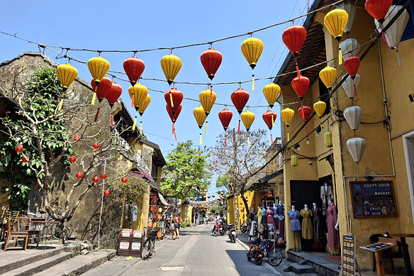
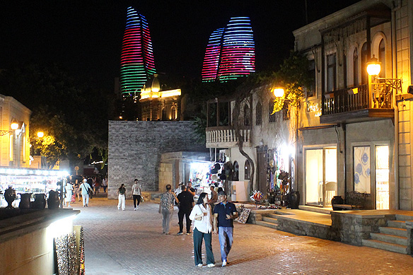
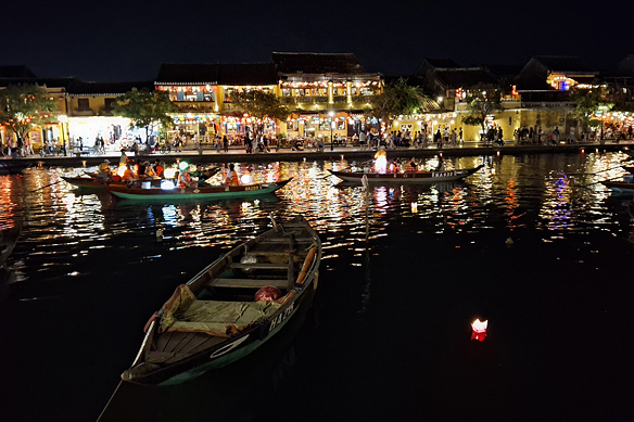
Imagine a whole town swathed in deep red and yellow silk lanterns. Across tree-lined streets and narrow alleys, on shopfronts and cutesy cafes. A centuries-old town with yellow tube houses that stretched between lanes, and a wide placid river that gently lapped against its banks.

If during the day Hoi An is a fairytale, at night it is as if those very fairies had waved a wand and created magic. Don’t be surprised if you catch yourself wondering if it was all for real. After all it is the 21st Century. How did this exquisite time capsule manage to survive. Especially one that was authentic, and not contrived.

Frozen somewhere in the 17th and 18th Centuries, UNESCO-listed Hoi An’s very name recounts its story. Hoi An means the ‘peaceful meeting place.’ Four hundred years ago, this idyllic riverside town became an international trading port in southeast Asia. Merchant vessels and traders from Japan, China, Europe, and India converged on its waterfronts and streets exchanging goods and ideas. Hoi An was their ‘peaceful meeting place.’

However, when neighbouring Da Nang started to grow as a port in the 19th Century, Hoi An’s fortunes fell and the town was forgotten. No one saw any merit in pumping money into building over its yellow trading tube homes and colourful assembly halls in the name of development. It was this very neglect which turned out to be Hoi An’s blessing in disguise and the reason for its revival, thanks to help from a completely unexpected quarter—Kazimierz Kwiatkowski, a Polish architect and conservationist.

If Hoi An is on every traveller’s bucket-list today, it is because Kwiatkowski spent years towards getting it listed as a UNESCO World Heritage Site. Hoi An never forgot the favour. A memorial in his honour stands in Kazik Park in the Old Town today.

Continue reading

top 15 memorable things to do in bahrain, pearl of the persian gulf

Fishing boats in historical Al-Muharraq overlooking modern Manama.

Fishing boats in historical Al-Muharraq overlooking modern Manama.

Bahrain, meaning ‘Two Seas’ in Arabic, is one of those delicious treats one encounters as a traveller. I do not mean that from a food perspective. Do not get me wrong. The food is fantastic here. What I mean is that it is a visual and historical treat. Layered, nuanced, and whole.

Middle East’s smallest country, the Kingdom of Bahrain is located a mere 25 kilometres off the north-east coast of Saudi Arabia. Ruled by the Al-Khalifa family, it is an archipelago of 33 islands with Bahrain Island the largest [51 kilometres long and 18 kilometres wide] and Manama as its capital. Though mainly barren desert, its freshwater underground springs and marine waters have given the country a remarkable gift: the finest Pinctada radiata oyster beds in the world, of which one in every 20 contains an iridescent natural pearl.

Since their discovery over four thousand years ago by the Dilmun civilization, these oyster beds have sustained empires who made Bahrain their home, and provided them with immense wealth. Pearl-diving, however, was no mean feat across these millennia. It was dangerous and physically demanding.

The divers, known as ghawwas, would plunge some 30 metres into the depths of the sea, armed with rudimentary nose clips and finger protectors, to collect the oysters. After gathering as many as they could with their breaths held tight, they would rush back to the surface, gasping for air. The oysters would be slit open, the pearls graded, and the wheeling and dealing begun with buyers from Europe and India. Once the prices were fixed, these little gems of nature left Bahrain’s shores to grace a crown, a robe, or a neck.

Everyone in the island was directly or indirectly involved in the business of pearls which peaked from 1810 to 1923 in Al-Muharraq, the second largest island in Bahrain. The result was a single product economy which made it to the UNESCO World Heritage list in 2012.

Any surprises then that Bahrain is often referred to by its moniker ‘Pearl of the Gulf?’

But what starts, ends. And though the oyster beds are still there, the pearling trade collapsed with the advent of the Japanese cultured pearl in the 1920s—a simpler, cheaper, and easier alternative—and the discovery of oil in Bahrain in 1932.

An Islamic nation based on Sharia Law, Bahrain’s maritime trade and exposure to multiple cultures for over four millennia has made it forward-thinking and tolerant. It is hard to distinguish between the Bahraini and 55 percent expatriate community at times. There is an easy comradery that cuts across race, class, and creed, peppered with some of the warmest, friendliest smiles around.

Here are 15 memorable things to do in Bahrain. Because, this little island kingdom is, well, different. ❤

Children dressed up for Bahrain's national day, 16th December, which celebrates the late Emir Isa bin Salman Al-Kalifa's ascension to power in 1961.

Children dressed up for Bahrain’s national day, 16th December, which celebrates the late Emir Isa bin Salman Al-Kalifa’s ascension to power in 1961.

Continue reading

photo essay: mountains, desert, and coast of northern oman

If you look closely at Oman’s map you will notice a peculiar detail. There is the mainland, and separated from it is its governate Musandam on a peninsula jutting into the Strait of Hormuz. Look more closely. You will see an exclave [called Madha] between the two that is surrounded by the UAE. Look at it even more closely. Within Madha is Nahwa, an enclave that belongs to the UAE.

Now you may well ask, how did this happen?

Somewhere around the late-1930s, the four rival sheikhs controlling the surrounding area asked Madha’s village elders who did they want to pledge their allegiance to? Madha chose the Sultanate of Oman, but the bit inside it called Nahwa chose the Arab Emirates. Based on their choice, the rather unusual border between the UAE and Oman was drawn out in 1969.

That is Oman for you.

The eclectic set of borders further transposes into an eclectic set of mountains, desert, and coastline, juxtaposed right next to each other. It is as if the gods asked them too, whose realm did they choose, and they all in unison said “Oman.”

Described as a geologist’s paradise, the oldest continuously independent nation in the Arab World [since 1650] has held on to its authenticity well. Despite being a high-income country, there is no rivalry for high rises in the Sultanate of Oman, nor glitzy shows of oil wealth.

Come travel with me through my photo essay across northern Oman as I take you from Muscat to Fins Beach via the Bimmah Sinkhole and Wadi Tiwi, on to Ras Al-Hadd to see turtles and Sur to see dhows, camp under the stars in the Sharqiya Sands, stop by at a Bedouin market in Sinaw, have meals at traditional mud settlements, drive offroad to the top of Jebel Shams and then down Wadi Bani Awf, to be back in Muscat. And on the way, learn about this fascinating country and its warm, laid-back, friendly people. ❤


The journey begins. Continue reading

salalah: middle east’s anomaly

Tucked away on the Arabian Peninsula’s south-east coast is the Middle Eastern’s favourite getaway. Salalah.

Its very mention brings about a soft sweet smile to their otherwise calm controlled air, and a sparkle to dark eyes.

“Aah, Salalah!” followed with unbridled joy that I will be making the journey across a thousand kilometres from Muscat to this ‘haven.’

For two months in a year, July and August to be precise, Salalah in Southern Oman is engulfed in dense moist cloud and fog, with a light drizzle that amounts to less than a monthly average of an inch. This season is lovingly called ‘khareef,’ even though the term technically means autumn.

During these two monsoon months the barren shrivelled lunar landscape morphs into gushing waterfalls, turquoise-blue rivers, and lush green vegetation, replete with coconuts and bananas.

Whilst the rest of the Middle East swelters at 50 degrees, its populace flock to this anomaly in droves. Carnivals brighten the choppy sea-shores, and long queues together with packed car-parks peak to a frenzy.

Not your cup of tea?

Salalah is just as delightful in December when like the rest of Oman, it enjoys perfect weather. Continue reading

mud, petroglyphs, oil, and fire: quintessentially azerbaijan

Sandwiched in the Caucasus, between the Caspian and Black Seas, Azerbaijan is a bit of a latecomer to global tourism. But catching up fast.

Unusual on multiple counts, four features and their unique mix set the country even further apart from the ordinary: Mud, petroglyphs, oil, and fire. Where else can one find such a cocktail! To add to its appeal, they come candy-wrapped in picturesque settings at a short distance from the capital Baku in the surrounding Absheron Peninsula.

Of the 700 mud volcanoes found around our planet, 40 percent lie in Azerbaijan. They bubble away on barren stretches courtesy of methane gas trapped under the earth’s crust. When the pressurized gas encounters groundwater, and together they find an opening in a fault line, they ooze out in the form of mud, cool to the touch.

Ranging from 1 to 700 metres high, and a few centimetres to a few kilometres wide, they function similarly to regular volcanoes. When they erupt, they can spew flames and mud from the bowels of the earth. Kinezadagh [397 metres high] and Turaghay [400 metres high] are the largest mud volcanoes in the country.

Azerbaijan is also among the oldest inhabited regions in the world, going back to the Stone Age. The Gobustan Rock Art Cultural Landscape Reserve, a UNESCO-listed World Heritage Site, contains an exceptionally large collection of petroglyphs. Etched into rock with sharp stone tools, and with the advent of the Bronze and Iron Ages, with metal, the earliest of the lot is 40,000 years old.

Subjects range from dancing figures, shamans, boats with oarsmen, and battle and hunting scenes; the latter replete with bison, gazelles, horses, and goats. Some of these were ‘drawn’ even before the region’s ancient men and women shifted to farming and husbandry as a source of food. Continue reading

72 hours in baku

Baku is often described as one of the most beautiful cities in the world. It is a description that is not off the mark. The city’s rich heritage spanning three millennia can be invariably seen in a single line of vision. Now where else would you have such a splendid view!

But Baku is not only about pretty buildings. A world city in every respect, it abounds with museums and galleries wherein local meets international. Literature, art, and music thrive here, both at the esoteric and popular levels. Can the culinary be far behind in all this? With one-fourth of Azerbaijan’s population, Baku buzzes with life. Literally. Not in a chaotic haphazard way. But as a celebration.

Travellers have only recently started noticing this city on the shores of the Caspian Sea which comes with the moniker ‘Windy City.’ On its part, the Azerbaijan government is making every effort to ensure it is a memorable visit. The visa department sends out surveys to its tourists to find out what worked, what did not, and how Azerbaijan could be a better travel destination.

Here is a three day/ 72-hour itinerary with context, tips, and links to help you make the most of your stay. To go straight to the itinerary for a specific day, use the table of contents below. Wishing you happy travels, this time to Baku. 🙂

Table of Contents:

Continue reading

the road less travelled: azerbaijan’s unusual villages

In just five to six hours, one can traverse across Azerbaijan’s length or breadth, crossing nine of the world’s 11 climatic zones along the way. And whilst at it, you would most likely not pass another soul.

Of Azerbaijan’s population amounting to just over 10 million, almost half of these live and work in the capital city Baku and the surrounding Absheron peninsula. The rest of the country is deserted. A tiny village tucked away in a forest-canopied valley or perched on a mist-wrapped mountain is as busy as it gets, apart from a handful of administrative and historical towns.

Nature is at its most magnificent on these stretches, free of exploitation for commercial gains and plastic waste. It is a setting which has also created some of the world’s most unique villages.

Take for instance Lahij, a thousand-year-old Persian village on the southern slopes of the Greater Caucasus Mountains. Unable to find suitable building material, the villagers created an entire settlement of homes and roads with river boulders. Over the centuries they also developed copper handicrafts of exquisite workmanship. It is a craft that is still practiced by its residents and has been listed in UNESCO’s Intangible Cultural Heritage of Humanity.

Then there are the villages in Lerik district in the foothills of the Talysh Mountains in south-east Azerbaijan where centenarians are the norm. Home to some of the oldest people that have ever lived on earth, the Talysh people, also of Persian descent, can be seen working on their fields and grinning cheerfully way into their hundredth birthday. At 90, they would be quick to exclaim that they still felt incredibly young!

If Lerik is about villagers renowned for their longevity, Khinalig high up in the Greater Caucasus range is the oldest inhabited village in the world—historians place it at 5,000 years. Its semi-nomadic villagers travelling between pastures have their own language, possess a distinct genetic make-up, and till recently had no contact with the rest of the world. Together with the mountains encircling it, the village and its inhabitants are a UNESCO-listed World Heritage Site.

Fascinating, isn’t it? Here are some more insights into these villages and their incredible secrets on the road less travelled, this time in the mountains of Azerbaijan.

Oh, and when on that road, don’t forget to have a qutab and chai from one of the many eateries nestled deep in dark lush forests. 😊 Continue reading

travel shorts: a tale of two heritage cities—shamakhi and sheki in azerbaijan

This slideshow requires JavaScript.

This is the tale of two cities in the land of fire, oil, and gas: Shamakhi where Azerbaijan’s rich medieval heritage took birth. And Sheki, which witnessed this same heritage’s closing chapter before the country was enveloped, first into the Russian empire and soon after, into the Soviet Union.

One specific dynasty’s rule had dominated Azerbaijan’s windswept plains and highlands in the Middle Ages. They were the Shirvan Shahs who ruled the Shirvan region, and whose capital Shamakhi was a trading post on the famed Silk Road.

Such was the glory and power of the Shirvan Shahs that their capital Shamakhi flourished for seven hundred years, from the 9th to 15th Centuries. When it did end its role as their capital, it was only because of nature’s unpredictable jostles. Shamakhi was prone to earthquakes. In the 15th Century, after one of the worst earthquakes the city had seen till then, its rulers felt it was wiser to move their capital lock-stock-and-barrel to Baku.

Most of Shamakhi was razed to the ground in this earthquake. Except for Juma Mosque, Caucasus’ second oldest mosque dating to 743. Juma or Friday Mosque has consistently, and lovingly, always been restored over the centuries. Its most recent face-lift was in 2013. Continue reading

the complete travel guide to the treasures of sri lanka’s cultural triangle

Welcome to my travel guide on Sri Lanka’s Cultural Triangle told a bit differently—through short photo-essay chapters on the country’s ancient and medieval history.

Of the six UNESCO-listed cultural world heritage sites in Sri Lanka, five lie within the Cultural Triangle in the heart of the country. It is a region rooted in 2,500 years of history and heritage, both sacred and secular, from timeless Theravada Buddhist sites to splendid Sinhalese royal capitals. All surrounded in lush tropical jungles.

Before I write any further, I would like to briefly explain two terms used in this guide which are part of the warp and woof of the country. Theravada Buddhism and ‘Sinhalese.’ Theravada Buddhism is the oldest school of Buddhism and a direct offshoot of Buddha’s teachings. There are five countries in the world which have Theravada Buddhism as their official religion, and Sri Lanka is one of them. Sinhalese refers to the Indo-Aryan ethnic race native to Sri Lanka.

Whilst this guide covers the five UNESCO-listed sites, it also includes some gems scattered in-between. I hope you find it useful and it helps put the country’s Cultural Triangle as a seamless whole with all the dots connected. ❤

[Title photo: 18th Century Mural at Lankatilaka Vihara, Kandy.]

Table of Contents:

Continue reading

travel diaries: hiking through the horton plains

There is a deafening silence as I enter the Horton Plains in the wee hours of the morning. Above me, the silver sun is still trying to find its way back into the sky. It is not an easy task.

A thick blanket of mist and cloud engulf me, the golden blades of montane grass, and the sand-spattered 3.5-billion-year-old Precambrian-era boulders. Every now and then a slight drizzle kisses my upturned face. I peer through the mist, strain my ears for another human sound. A footstep, laugh, threads of a conversation. All I can hear is my own breath. I look at my phone. There is no signal. Continue reading